
Large scale El Niño patterns in the ocean and atmosphere manifest themselves in anomalous conditions at the coast (including increased ocean temperature and altered sea level) and sometimes in weather patterns (timing and amount of precipitation). These conditions can impact estuaries and the coast both from the downstream (ocean) end as well as from the upstream (freshwater) end.
See below to see how you can help study coastal effects of extreme sea level events as a community scientist!
extreme water levels
The anomalously warm eastern Pacific Ocean during an El Niño leads to a sea level rise (warm water expands relative to cold in addition to atmospheric pressure affects). The 2015-2016 El Niño contributed ~8 inches of enhanced sea level along the California coastline. In addition to this background enhanced sea level, El Niño is often accompanied by increased storms hitting the California coastline, this includes large wave and swell events (increased water level) as well as the potential for large rainfall events. The total sea level experienced at any coastal location is a combination of the background sea level + tides + waves + swell + upstream freshwater. With an enhanced background sea level, the likelihood for extreme sea level events increases (even with average tides + waves). The co-occurrence of extreme tides during the end of November, December, and January (nicknamed “King Tides”), as well as increased storms enhances the odds of extreme water level events even further.
the 2015-2016 El Niño
The 2015-2016 El Niño was one of the largest on record based on the oceanic heat anomaly. Prior comparable El Niño conditions occurred in 1997-1998 and 1983-1984, both of which brought devastating coastal impacts.
We took advantage of the 2015-2015 El Niño season to study the coastal response to extreme events and use the results as a window into future sea level rise conditions. Sea level has already risen ~7 inches over the past century and is predicted to accelerate in pace. The 2015-2016 El Niño contribution of ~8 inches enhanced background sea level is similar to conditions that are expected to occur in as little as 35-45 years from 2015 based on predictions by the IPCC.
extreme tides and extreme coastal water levels
The co-occurrence of extreme tides during the end of November, December, and January (nicknamed “King Tides”), as well as storms during the winter season (regardless of El Niño conditions or not) makes this time of year susceptible to extreme water level events.
what are we measuring?
Scientists throughout the region are measuring flooding impacts as well as morphological changes (erosion/accretion) of cliffs, beaches, estuaries, and man-made structures. Our lab is specifically looking at the response of estuaries to extreme events including their morphodynamic evolution, hydrodynamic response, and the resulting ecosystem impacts. Other scientists at Scripps Institution of Oceanography are tracking coastal flooding along infrastructure such as roads, measuring beach erosion and potential sand berm breaching. Collaborations with scientists up and down the California coast from the Southern California Coastal Water Research Project, UC Santa Barbara, Cal State Long Beach, UC Davis, the United States Geological Survey, the NOAA National Estuarine Research Reserve, and more are joining together to expand observations state-wide.
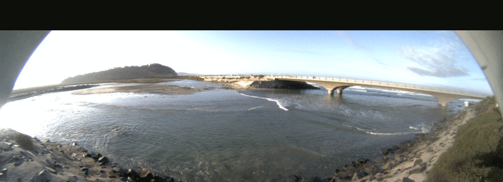
Time lapse images overlooking the mouth of Los Penasquitos Lagoon showing the value of high tide images (waves + inundation) and low tide images (bathymetry + estuary state). Thanks to the Tijuana National Estuarine Research Reserve and the System-Wide Monitoring Program (SWMP), particularly Michelle Cordrey data access and maintenance.
We are hoping to involve community scientists in our research efforts through the use of photographs and limited water sampling. For the photograph collection, we have joined in collaborations led by USC Sea Grant and the Southern California Coastal Ocean Observing System to centralize our efforts and expand our reach.
photographs: We would benefit from photographs of lagoon & estuary mouths, lagoon & estuary overlooks, coastal roadways, seawalls, berms, cliffs, and beaches. The most beneficial photographs will be those taken
- regularly from the same location and angle (e.g., once per week or once per day) including low and high tides
- with a fixed reference point within the field of view (e.g., a bridge edge)
- documenting large erosion or inundation events after a storm passes
Note that as mentioned above we are teaming up with several other groups to turn this into an all-inclusive community science photographic collection event. Including working with the Tijuana National Estuarine Research Reserve in turning this into a competition! To participate and see maps of desired photograph locations, please see the Urban Tides Initiative website to download the app, read instructions, and start photographing! See results from a trial of this Urban Tides program here. If you prefer not to use an app, but rather email, you can email your photos to stormphoto at sccoos.org (information here). Also see additional information from our partners at the National Estuarine Research Reserve. Note that you do not have to stick to the map nor to a frequent & regular schedule, but as explained earlier, the more regular the photographs, the more valuable they are to us as scientists!

“King Tide” 25 November 2015, photograph taken by Kristin Brinner, Surfrider San Diego Chapter from the North Bluff Preserve overlooking Dog Beach and the San Dieguito Lagoon mouth.

Images taken from the CA State Parks parking lot north of Los Penasquitos Lagoon mouth overlooking the mouth and Torrey Pines in the background. These images show the drastic morphodynamic evolution that can occur over a matter of days, shifting the channel substantially. Time lapse images overlooking the mouth of Los Penasquitos Lagoon showing the value of high tide images (waves + inundation) and low tide images (bathymetry + estuary state). Thanks to the Tijuana National Estuarine Research Reserve and the System-Wide Monitoring Program (SWMP), particularly Michelle Cordrey for data access and maintenance.
directed beach and water samples: If individuals are particularly motivated to contribute further and have time to do so during the business day or they have a classroom group they would like to engage, we have additional surveys and data collection that community scientists could contribute towards including
- water samples of salinity, temperature, and depth taken from a hand-held instrument
- estuary mouth cross-sectional surveys
- beach elevation surveys
These opportunities would require
- training with SIO scientists
- a firm commitment from the community scientists that they will participate regularly in the monitoring activities on an agreed-upon schedule.
If you are interested in participating in this way, please contact Sarah Giddings and/or Madeleine Harvey.