With two grants from the California Department of Parks and Recreation Natural Resources Division – Coastal Program, our lab has been examining the interaction between estuary inlets and the adjacent beaches since 2017. The first grant (“Estuary Inlet Dynamics & Analysis”, July 2017- December 2021) was in collaboration with Dr. Timu Gallien (UCLA, Coastal Flood Lab) to examine the interaction between estuary inlets and the adjacent beaches. This work collected fundamental hydraulic and hydrodynamic data and monitored evolving estuary inlets and adjacent beaches at two California State Parks, Torrey Pines/Los Peñasquitos Lagoon and Cardiff State Beach/San Elijo Lagoon. For results from this first contract period, please see this page describing key results.
The second grant (“Estuary Inlet Evolution & Dynamics”, January 2022-December 2024) extends work started during the first grant with some new analyses and collaborative aspects that expand the scope and impact of the work to include Northern California systems through a collaboration with Dr. Mara Orescanin (NPS, Coastal Dynamics Lab). Moreover, this second contract seeks to improve output products in anticipation of a more holistic analysis of the results, geared towards managerial needs in future years. See a summary of results from this second project here.
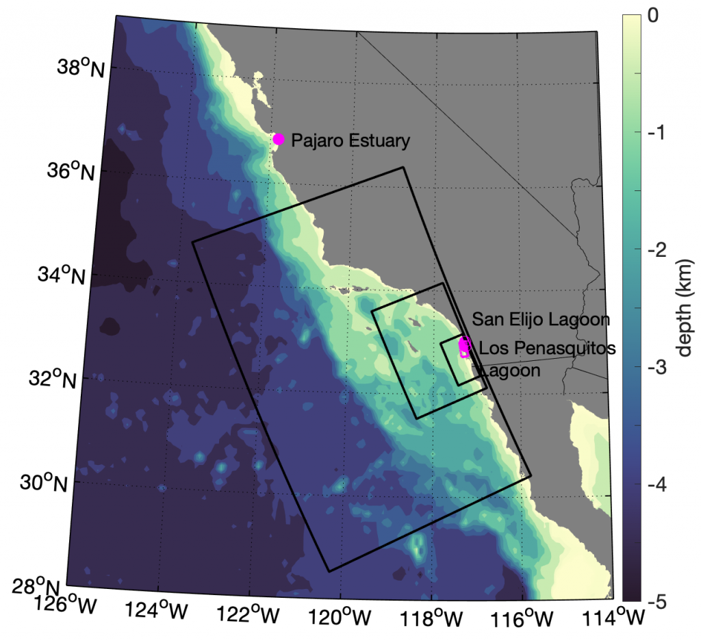
Through these two contracts, we have collected fundamental hydraulic and hydrodynamic data and monitored evolving estuary inlets and adjacent beaches at three California State Parks, Torrey Pines State Beach/Los Peñasquitos Lagoon, Cardiff State Beach/San Elijo Lagoon, and Zmudowski State Beach/Pajaro River Estuary (see Figure 1). Beach and estuary inlet shoreline and channel erosion data have been collected using wading real time kinematic surveys and a Parks-funded UAV and LiDAR. Our high resolution subaerial inlet and adjacent beach topography provides improved, site specific inlet information that will help inform when park facilities or infrastructure may be impacted by inlet closures or large erosion events. Moreover, this data collection and analysis provides key data for future coupled inlet-beach morphological modeling elucidating infrastructure and ecological hazards associated with sea level rise and increased streamflow. Additionally, this research furthers understanding of three unstabilized, nourished beach-estuarine systems. Climate change will alter estuary-beach feedbacks and, in the future, these systems may require increased management (nourishment, breaching) and potentially stabilization.
A 2019 augmentation award focused on supporting additional observational collection, as well as preliminary development of a realistic wave-current coupled hydrodynamic simulation for the Torrey Pines/Los Peñasquitos Lagoon region.

Figure 1. Regional map with Los Peñasquitos Lagoon, San Elijo Lagoon, and Pajaro Estuary mouths (pink dots). Offshore bathymetry is colored in blue. The locations of Nested model domains range from the coarsest resolution (LV1) to the second finest high- resolution wave-coupled child domains (LV2). Parent model horizontal resolution varies from 2 km (LV1) to 600 m (LV2) to 200 m (LV3) while child models (LV4, shown on Figure 2) have varying horizontal resolution from 8-100 m. The new LPL LV4 grid (part of contract C1670005 year 3 augmentation) encompasses Torrey Pines/Los Peñasquitos Lagoon and Cardiff State Beach/San Elijo Lagoon.
